
Storm Sailing to Wild Shores: Kayak Island & Cape St. Elias

A Coastal Excursion with Rich History and Rugged Terrain
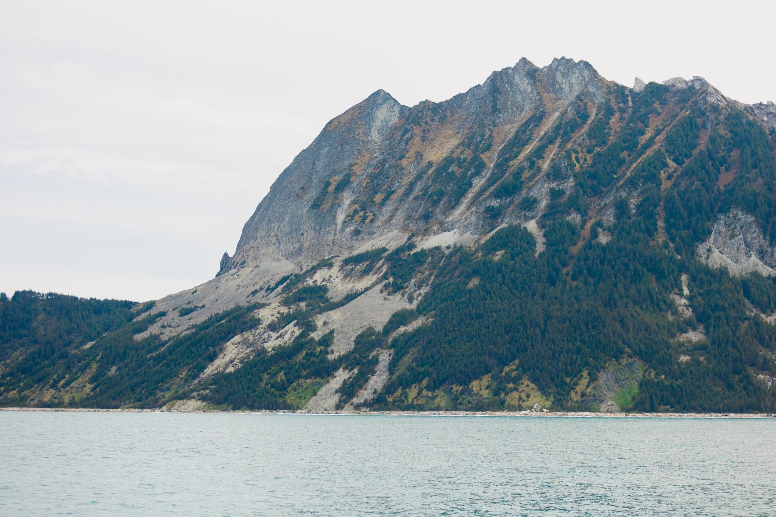
As we ventured further west from the rugged shores of Icy Bay, we found ourselves approaching Kayak Island, a place rich with history, natural beauty, and untamed wilderness. Located near the entrance of Prince William Sound and the mouth of Controller Bay, Kayak Island has long been a stop for explorers, from early mariners to those seeking solitude and adventure today. Its steep cliffs and sheltered coves, its distant lighthouse and mysterious, windswept beaches, all hold the stories of time gone by.
Cape St. Elias, Kayak Island
Storm Sailing West to Cape St. Elias
At the crack of dawn, we readied ourselves for the day's departure from Icy Bay. A storm was brewing which promised to deliver favorable winds for our westward journey to the far-flung Cape St. Elias on Kayak Island, 96 miles across the Gulf of Alaska.The storm was forecasted to be gale force – not the ideal weather for a voyage, but it was the only wind in the forecast that was pushing us toward our destination rather than against us. The choice was simple: sail forward or wait somewhat indefinitely. Mid-May still clung to the icy grip of late winter and early spring storms, and the Gulf can be very unforgiving. With winds forecasted 30 to 40 knots and seas building to 8 to 10 feet (waves cresting at 13). Seasoned by years of navigation, Louie was well aware of the potentially rough ride ahead and did his best to prepare me for what was to come.I can hardly recall the beginning of the day beyond the storm clouds gathering in the distance. It wasn’t long, though, before we were plunging into the monstrous waves, their towering crests pushing and surging us forward and sideways. Water in the engine room from the cutlass bearing drip system along with other points of infiltration, sloshed around the deepest depths of the bilge, collecting decades of debris that clogged the suction grate of the main bilge pump. The buildup of debris caused the automatic pump to cease functioning, and the waves were far too strong to fix it in the moment. Louie had to deploy the emergency bilge pump to get rid of the excess water from the engine room out the galley window. I sat in the enclosure of our dog house alone and watched as the vastness of the ocean seemed to dwarf us, and I found my panic building as the sea seemed to rise and fall endlessly around the vessel. I had little sailing experience at this point to measure the height of the waves, but their raw, overwhelming power was enough to make my heart race.As Louie stepped back into the dog house, he saw the concern in my eyes—my growing fear mirrored by the increasing size of the waves around us. A particularly large wave caught us, and we surfed over it with a force, followed by an even larger wave that washed over the deck, briefly flooding the doghouse in which we sat. “These are definitely 20 foot waves,” Louie said after a moment or two, confirming that my panic was founded. His calm demeanor felt like a stark contrast to what felt like chaos around us. Though I’d mentally prepared for this moment—knowing it would be new and frightening for me as a sailor—nothing could have truly prepared me besides just being in it. Soon tears of fear rolled down my face as I sat through wave after wave. Eventually I came to a stark realization that this would be our reality for the next 10 to 12 hours. There was no turning back – the only way out was through. It became a matter of accepting the storm, leaning into the inevitable rise and fall of the waves, and simply holding on.
Cape St. Elias, Kayak Island
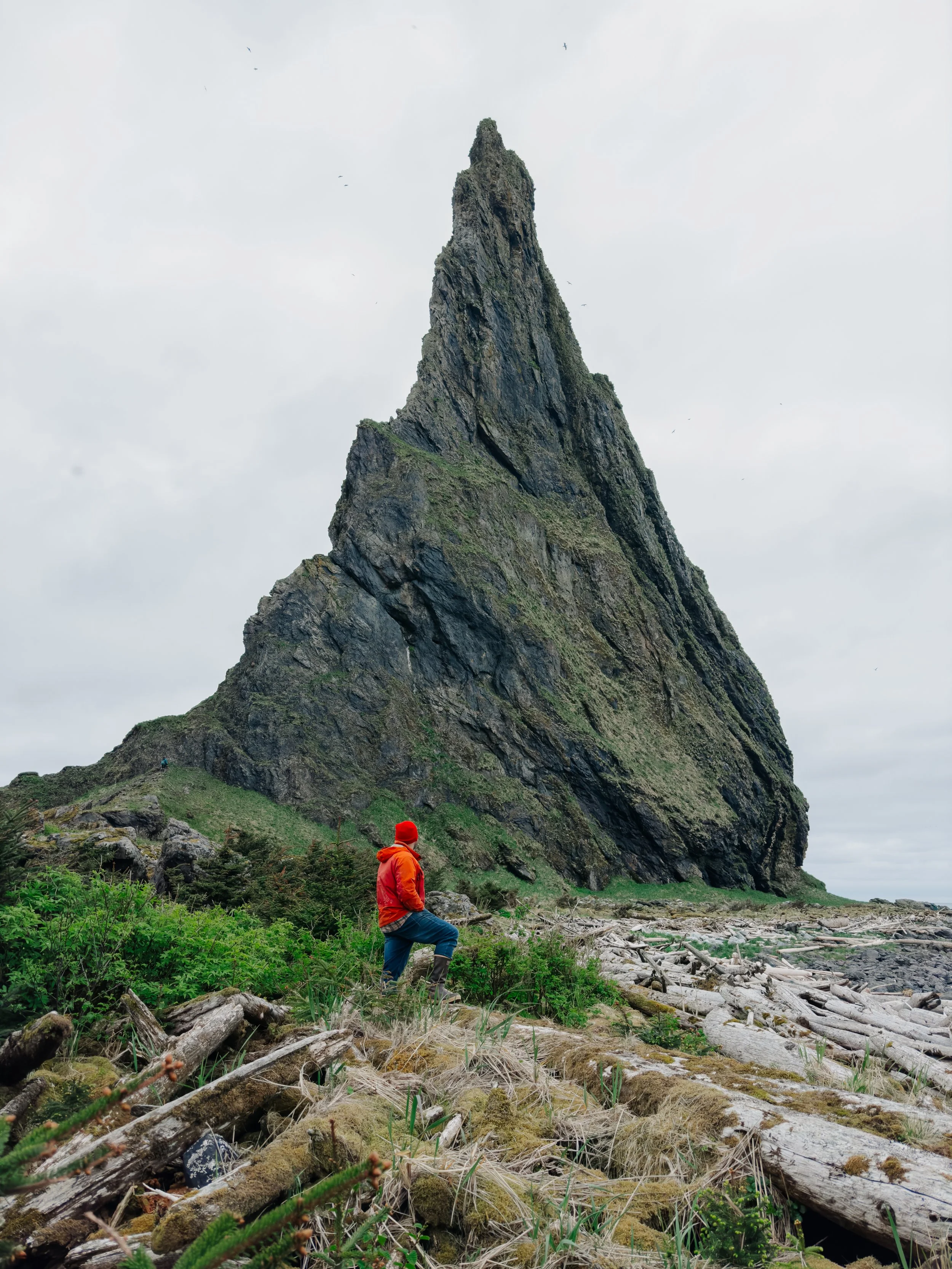
Halfway through our journey, we broke into what could only be described as the eye of the storm. Blue skies and bright sunshine suddenly shined through brilliantly, illuminating the cobalt blue ocean. Seabirds soared above us while the wind still howled and the seas were still sheerly massive. It did however feel as though we had crossed into a new world, one where the storm had been swallowed whole by the horizon behind us, leaving behind only the tumultuous seas.Several hours later we entered the storm clouds again as we neared Cape St. Elias. The iconic shark fin shaped rock loomed large in the distance, a harbinger that our day’s odyssey was nearing its end. The jagged rock rises sharply from the ocean, a natural feature that commands attention – both ominous and intriguing. With the lighthouse now visible in the distance, the strange geography of the cape unfolded before us. The waters surrounding Cape St. Elias are notorious for their swift currents, dense fog, and ever-changing tides. The winds here can shift without warning, and the seas follow suit, creating an environment fraught with danger for any sailor brave enough to navigate these treacherous waters. Mariners of old had to approach with caution, as the visibility was often poor, and the seas mercilessly churned around them. Many have recounted the difficulty in spotting the cape itself, even when it was within sight, as the turbulent waters often concealed the landmark in a haze of mist and swell. The cape’s unforgiving nature has claimed its fair share of ships, with numerous wrecks scattered along the coastline. We anchored on the north west side of the island in the shelter of the cape and decided to spend the next two days exploring the rugged beauty of the area, recovering from the wild journey and marveling at the unique landscape of this remote corner of Alaska. Alas, we made it through the storm. 
Cape St. Elias Lighthouse, Kayak Island
Cliffs of Kayak Island
A Day on Wingham Island
The morning after our adventurous sail, we set about cleaning the remnants of the chaos that often follows a day at sea. As the afternoon sun cast its golden light upon the waters, we set our sights on Wingham Island, Kayak Island's elusive neighbor. Tucked at the mouth of Controller Bay in South-Central Alaska, this island is woven with tales of exploration, mining, and scientific inquiry.Wingham Island is not often spoken of as Kayak Island’s less popular neighbor, though whispers of a long-forgotten town from the late 19th century echo through the pages of old maps. We had heard of the settlement, but attainable details were sparse, with little to be found on either modern or vintage charts marking its precise location. Undeterred, we ventured into the island's thick forest, hoping to uncover clues from a time past. Our search led us to the southern shore, where the remnants of a cannery lay scattered like forgotten ghosts, the timbers long weathered by the salt and wind.
Abandoned canny ruins on Wingham Island near Kayak Island
As we wandered further north along the eastern beach, we were struck by the unexpected sight of piles and piles of washed up trash. Kayak Island is known for being a filtration point for beach trash that floats over from Asia, and what does not end up on Kayak Island often makes its way to Wingham Island. We walked for hours, discovering an endless array of plastic bottles, rubber boots, ship lightbulbs, plastic fishing floats, and a myriad of other refuse items lost to the sea and carried many hundreds, if not thousands, of miles to this remote shore. Yet amid the litter, there lay a treasure trove of the unexpected as I spotted a glass fishing float, that most coveted of finds along Alaska’s shores. Known to us as "glass balls," they are revered as the true treasures of the sea. To stumble upon one felt like a small victory against the relentless tide of modern waste—a reminder of the ocean's mysterious gifts, and the legacy it leaves behind.
S/V Arcturus from Wingham Island with Kayak Island in the background


Jet rafting to Wingham Island
Cape St. Elias Lighthouse
The next morning, overcast skies greeted us with a promise of adventure as we set out towards Cape St. Elias and its storied lighthouse. Reaching shore was no easy feat, with the rocky coastline entwined in a tangle of kelp, and the tides offering little mercy. Timing was everything—our raft batted and bounced on the waves as we maneuvered toward the beach. As we stepped ashore and wandered closer to the lighthouse grounds, we caught sight of Lupine beginning to bloom. It was a gentle sign that summer's warm breath was not far off.
Lupine blooming in front of Cape St. Elias
The lighthouse itself stands as a proud sentinel against the wild and often treacherous waters of the Gulf of Alaska. Perched atop a rugged cliffside and built in 1915, its guiding light has been a beacon for mariners braving the fogs and rocky shores of this perilous stretch of coastline. The very essence of isolation is woven into its history, for the lighthouse has overlooked these seas for over a century, its role steadfast in helping to prevent shipwrecks. In 1998, the original lens, now a part of the Cordova Museum, was replaced by a solar-powered Vega optic, a modern upgrade in keeping with the times. Added to the National Register of Historic Places in 1975, the lighthouse’s continued glow is a testament to Alaska’s maritime heritage. Though automated in 1974, its light still cuts through the gloom, guiding vessels through some of the wildest and most dangerous waters along the coast.
Cape St. Elias Lighthouse

Cape St. Elias Lighthouse

Path to Cape St. Elias Lighthouse

Inside the light tower of Cape St. Elias Lighthouse
As we approached the lighthouse grounds, a sense of eerie quiet settled over the place. The lighthouse, though standing proud, seemed to wear the weathered years like a forgotten sentinel, its surroundings in a state of disrepair. The grounds themselves held a haunting presence—remnants of another time, now fading away with the wind and tide.Wandering further, we recalled research we’d done about an artist retreat on Kayak Island and eventually we stumbled upon the unexpected building—a humble refuge for artists, complete with modest bunks and a kitchen. Surrounded by nothing but wilderness, it was easy to imagine how one could find inspiration here, disconnected from the rest of the world. Much like Icy Bay, the overwhelming feeling of remoteness on Kayak Island was a constant companion, echoing through every quiet breeze and crashing wave.
View from front porch of the Cape St. Elias Lighthouse Artist Retreat

Interior decor of the Artist's Retreat

Interior decor of Artist's Retreat

Cape St. Elias Lighthouse

Cape St. Elias Lighthouse on Kayak Island
Further along the rocky shore, we came across less beach trash than we had on Wingham Island—likely the result of organized clean-ups that are more common here. However, we did find a large NOAA weather buoy that had washed up, a reminder of the vast, sometimes unpredictable forces at play in these wild waters. As we neared the great rock at the point, we were greeted by the incredible spectacle of seabirds circling overhead, their calls mingling with the wind, and a sealion rookery nestled upon the rocks below. The island’s natural beauty was still as wild and untamed as it had ever been, and we felt incredibly small in its vast presence.
Washed up NOAA weather buoy
Onward to Prince William Sound
We awoke after our time on Kayak Island with another long sailing day ahead of us, this time making our way toward the entrance of Prince William Sound. The journey ahead loomed large—over 100 miles to sail—but the winds of fortune were with us, and the day unfolded in stark contrast to the tempestuous journey that had come before.We set sail at 10 a.m. and hoisted the two foresails wing on wing, catching the wind perfectly as it pushed us onward. The engine was silenced just 15 minutes after our departure, and from that moment on, the course was steady, the sails full, with no need for further adjustments for the next 10 hours. Cruising at 10-12 knots, there was no struggle against the wind; it carried us effortlessly across the water. It was a day so perfectly serene, so fluid in its simplicity, that to this day it remains one of the most satisfying and peaceful days we’ve ever had under sail.With Prince William Sound awaiting, we could hardly contain our excitement for the next chapter of our adventure. The promise of its pristine waters and new landscapes to explore made the final stretch of our journey all the more rewarding. We looked forward to spending the rest of May and all of June immersed in its beauty, knowing the wild majesty of the Sound would continue to captivate us with every passing day.
Cape St. Elias on Kayak Island
Cape St. Elias on Kayak Island
A Reflection on Time and the Sea
A word of honesty: this blog post took me months to craft, and for reasons far deeper than mere busyness. The very days I chose to write about this experience, months later while sailing the coast of Canada and the western shores of Washington and Oregon, coincided with some of the subsequently challenging storm sails we’d encountered on our journey. The irony is not lost on me.As I complete these words sitting in the much calmer Sea of Cortez – now over 7,000 miles into our journey – the quiet of the sea offers space to reflect. As a photographer, I’ve come to realize that certain moments, especially those of remote turbulence or trauma, require time to truly process. The weight of these experiences, whether captured through words or images, often lingers, demanding reflection before they can fully be shared with the world. In the end, it’s not just the journey that takes time; it’s the act of making sense of it all that slows the pace.
Cape St. Elias, Kayak Island
Adventures, Words & Photos by Lerina Winter & Captain Louis Hoock
Navigational Considerations for Kayak Island

Kayak Island should be approached from the SW. While there is a shallow passage to the NE of the island, it is only navigable by shallow-draft vessels in ideal weather conditions. With SE winds, the NE shallow passage may have large breaking surf. When rounding the cape, vessels may pass either N or S of the #2 buoy depending on surf conditions, as wave height builds off the underwater rocky pinnacles of Cape St. Elias. These submerged pinnacles extend far SW from the corner of the island and have claimed many ships over time.The anchorage to the E of the lighthouse is only suitable in NW winds, as it is exposed to S swells. Most fishing vessels and boats that frequent the area anchor on the NW side of the island, just S of Pyramid Peak. The area N of Pyramid Peak is inaccurately charted and has poor holding ground. It is possible to enter the Kayak Entrance NW of Kayak Island and SE of Wingham Island, just before high tide with an incoming tide. The shallows between the islands are protected in most weather conditions, but they are shallow and have strong currents.Landing a raft on the NW shore of the lighthouse is possible, and that is where we chose to make landfall. However, there is a large area of rocks that creates a challenging surf break when coming and going. An easier landing may be found at the SE anchorage, though it is weather and surf-dependent.