
Where Mountains Meet the Sea: Exploring Icy Bay

the ice-packed Remote wilderness and Towering Majesty of Mount St. Elias
With the early sunrises and late sunsets of mid-May upon us, we set our sights on the icy allure of Icy Bay, where new stories and untamed beauty await. Departing from Yakutat and heading northwest, we left familiar waters to brave uncharted territories that neither Louie nor I had ever explored by boat. With nine years of guiding experience through Southeast Alaska, Louie knows the Inside Passage like the back of his hand. As we sailed into the unknown, the wind grew scarce, and our journey northwest took on an almost dreamlike quality. We wondered if the winds would ever favor us, granting us the power and promise to reach the distant passage into Prince William Sound.Just north of Yakutat Bay, we first glimpsed the Malaspina Glacier, one of the largest piedmont glaciers in the world, sprawling over 1,500 square miles. Named after Italian explorer Alessandro Malaspina, who mapped the region in the late 18th century, this glacier is unique. Flowing out of the St. Elias Mountains, it spreads into a broad, fan-shaped ice field rather than terminating in the sea. Its surface is marked by moraines—ridges of debris left behind—creating a distinct pattern, like two liquids slowly churning together. From the sea, we caught glimpses of this icy expanse, where ice and earth meet in a slow, relentless dance.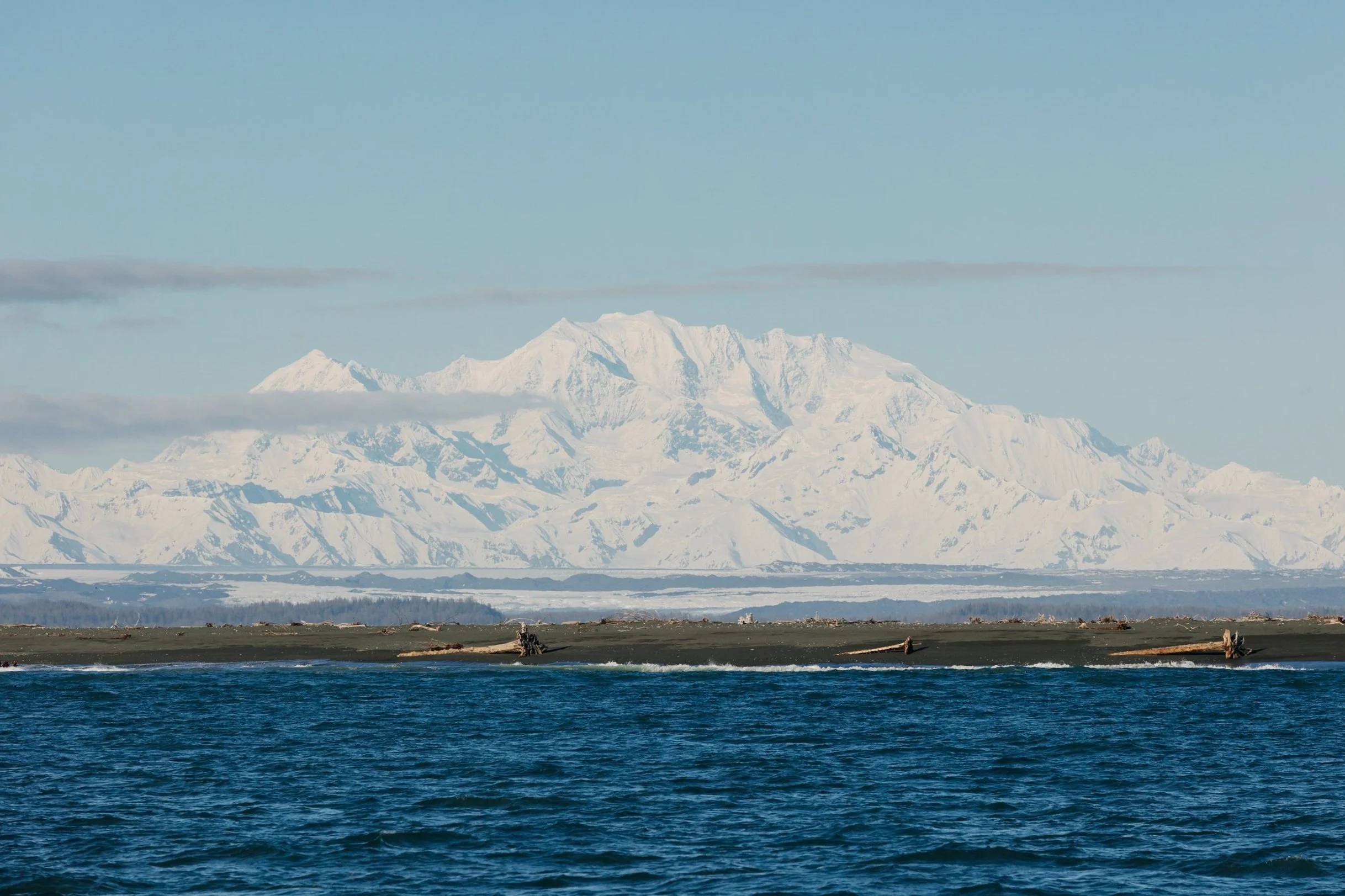
Pt. Riuo Spit With Malaspina Glacier and St. Elias Mountains In the background

Western side of The Entrance to Icy Bay
As we sailed further along the outer coast, the towering peaks of the Fairweather Range gave way to the majestic ascent of the St. Elias Mountains. Here, the mountains rise abruptly from the sea, crowned with vast icefields and glaciers that feed the rivers below. Reaching Icy Bay from Yakutat felt like stepping into an untouched world—a place so remote, it lies far from any town or trace of civilization. The modern world fades away here, leaving only raw, unspoiled wilderness. The isolation is palpable, measured not just in miles but in a profound sense of distance from everything familiar. To the north, Southcentral Alaska and Prince William Sound lie many days of travel away, while Southeast Alaska lingers as a distant memory. Even by Alaska's standards, Icy Bay epitomizes remoteness—a sanctuary for those seeking solitude and the profound beauty of the wild. Amidst this remoteness, however, there is a fishing and hunting lodge on the eastern side of Icy Bay and a logging operation on the western side.Icy Bay lies within the vast wilderness of Wrangell-St. Elias National Park & Preserve, safeguarded since 1980 by the Alaska National Interest Lands Conservation Act. This treasure is part of the Kluane/Wrangell–St. Elias/Glacier Bay/Tatshenshini-Alsek UNESCO World Heritage Site, spanning both Alaska and Canada. As we neared Icy Bay, Riuo Spit’s sprawling beach, strewn with colossal driftwood, came into view. Entering the bay, Mount St. Elias, standing at 18,008 feet, loomed closer, a majestic backdrop to our passage. One of North America’s tallest mountains, its dramatic rise from sea level marks it as one of the highest coastal peaks in the world.
Mount St. Elias from the entrance to Icy Bay

S/V Arcturus facing west towards the entrance of Icy Bay
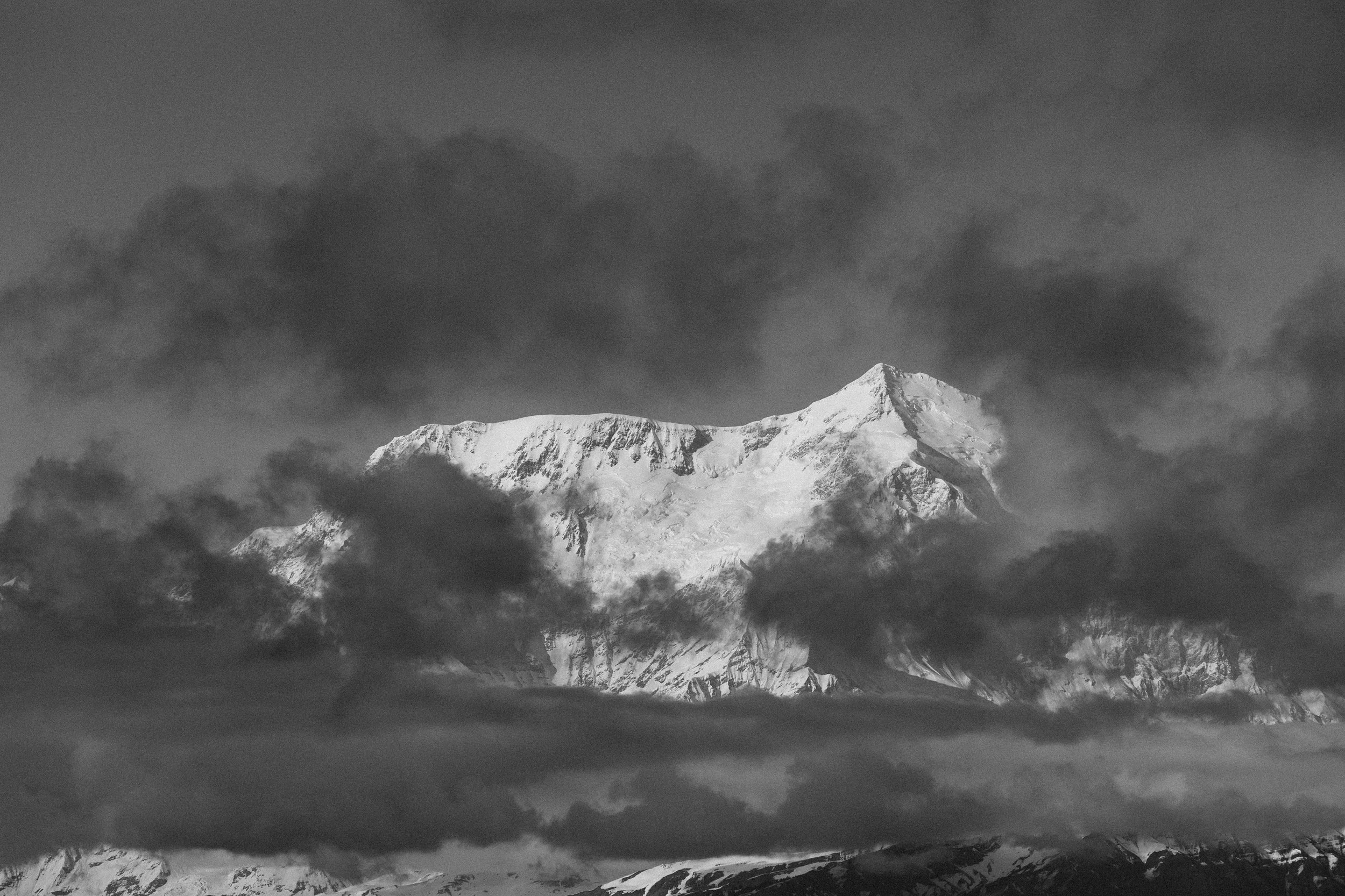
Mount St. Elias through the clouds
We anchored our first night in the sheltered Riuo Bay Cove, just behind the Pt. Riuo Spit beach. Eager to explore, we set off on a sunset beach walk, as the northern mountains were bathed in golden light. The beach, scattered with massive driftwood logs, resembled an endless elephant graveyard, stretching for miles, each log like ancient bones. The allure of this remote beach was irresistible, prompting another long walk the next morning. There’s nothing like walking along one of the most isolated shores in the world, where granite pebbles are perfectly rounded, and the fierce waves crash against the shore with untamed power. See navigational notes at the end of the post for guidance on entering Riuo Bay, which has a very shallow entrance.
Sunset at the beach on Pt. Riou Spit

S/V Arcturus in Riou Bay with Mount St. Elias in the background

Driftwood on the beach at Pt. Riou Spit

Driftwood on the beach at Pt. Riou Spit

Pebbles on the beach at Pt. Riou Spit
We turned inland, leaving the exposed shoreline behind to venture toward the forest, where a vast, swampy muskeg stretched before us like a silent guardian. Our steps soon led us through an endless expanse of strawberry flowers, freshly in bloom, their delicate petals opening like whispers of spring’s promise. The air was thick with life, and amidst the flowers, remnants of winter's wrath lay scattered—fishing floats and debris, relics of violent tides and storms that had lashed the coast. As we reached the opposite shoreline inside the bay, we paused to take in the breathtaking vista of Icy Bay, where the waters shimmered beneath the wide expanse of sky and mountains. Above us, seabirds wheeled and cried, their songs mingling with the wind, while below, the beach teemed with life, a sanctuary for migratory birds and mammals. This place proved to be a vital waypoint, not only for us explorers, but for the wild creatures that journey through its pristine waters and skies.
Driftwood and Muskeg on Pt. Riou Spit

Driftwood on the beach inside Riou Bay

Seabirds on the beach at Riou Bay
Icy Bay is a relatively recent geological formation, a landscape born in the last century and previously dominated by glaciers. In the early 1900s, maps of the coastline from Yakutat to Kayak Island showed only Icy Cape, with the bay itself yet to be revealed. A subsequent 1945 U.S Coast & Geodetic Survey chart showed the bay nearly filled by the retreat of Guyot Glacier, not yet split into the three glaciers now spilling into the bay. As we sailed deeper into Icy Bay the next afternoon, we glimpsed Yahtse Glacier to the north, followed by the massive expanse of Guyot Glacier to the west. The name "Icy Bay" is a testament to the ceaseless calving of icebergs, a spectacle that has rapidly shaped this place since the mid-20th century. 
Survey Map of AlaskA's outer coast from Kayak Island to Yakutat, Circa 1909

U.S. Coast and Geodetic Survey chart of Icy Bay, circa 1945
Even today, the bay remains a maze of floating ice, which prevented us from venturing too close to these icy behemoths and the hidden wonders of Tsaa Fjord, south of both glaciers. S/V Arcturus is a heavy steel boat, and despite hundreds of days spent in glacial ice packs, this was the first time we found the ice flow too thick to even attempt traveling farther. That night, we anchored at Kageet Point at the mouth of Taan Fjord, with incredible glacier views of the ghostly blue Guyot Glacier. We even caught sight of a moose swimming in the water.
Guyot Glacier, Icy Bay, Alaska

Iceberg in front of Tsaa Fjord, Icy Bay, Alaska

Guyot Glacier, Icy Bay, Alaska
We next ventured up Taan Fjord toward the Tyndall Glacier, which rests at the base of Mount Saint Elias. As we navigated deeper into the fjord, the landscape unfolded like a painter’s palette, revealing unexpected hues and textures. The geology was captivating — strangely reminiscent of the American Southwest. The reddish-brown cliffs framing the fjord evoked the rugged beauty of Colorado, while the silty, mud-like runoff cascading down the cliffs reminded us of New Mexico’s Bisti Badlands. For Louie and me, both raised in the Southwest, this landscape was an uncanny juxtaposition, a surreal blend of two worlds. It felt as if the slow, relentless advance of mountains and glaciers had collided with the sun-baked mesas of the desert, creating a mismatched yet harmonious tapestry of earth and ice. Mariners should note that Taan Fjord has significant landslide risk that can produce regular tsunamis, as there is always an inherent risk due to earthquakes. This area should be avoided during heavy rainfall for this reason.
S/V Arcturus at the entrance of Taan Fjord with Mount St. Elias in the background

Tyndall Glacier in Taan Fjord with St. Elias Mountains

Landscape of Taan Fjord

Landscape of Taan Fjord

Landscape of Taan Fjord

Tyndall Glacier in Taan Fjord

S/V Arcturus in front of Tyndall Glacier in Taan FjorD

Louie & Lerina in front of Tyndall Glacier in Taan FjorD
Our final evening found us back at Kageet Point, graced by clear skies and the towering silhouette of Mount St. Elias as we prepared for the long, unbroken passage to Kayak Island and the entrance of Controller Bay—a daunting 96-mile stretch with no harbor in sight. At last, the winds promised to be in our favor. As night descended, our crewmate rushed below, whispering of faint auroras dancing above the peaks. Though the midnight skies of mid-May remained light, ethereal bands of green swirled briefly, bidding us farewell before the summer’s lingering daylight would chase them from view. This fleeting glimpse of the northern lights felt like a secret shared only with those daring enough to roam these wild, untamed lands. We knew that once we left these remote waters, the mystical lights would remain hidden, masked by either the endless sun or the misty veil of summer storms.
Kageet Point at sunset with Mount St. Elias
Adventures, Words & Photos by Lerina Winter & Captain Louis Hoock
Navigational considerations for entering riou Bay:
Entering Riou Bay is a shallow passage, yet the anchorage is well worth the effort. Hazards are clearly marked on Navionics® charts, but timing is crucial – The key is to navigate an hour or two before high tide, proceeding slowly and with caution. As Louie wisely says: “If you’re going to go aground, do it slowly, with the tide rising!” The holding ground here is great, and the glacial sediment clay provides secure anchorage. Shows here are photos of our route for reference.
